2019-Jul-07
July 7 Water Levels Report
Over the last week, much of the Great Lakes Basin has experienced warmer than average temperatures with the western and southern portions of the basin being the warmest with respect to their normal values. Most of the basin had near normal rainfall with the exception of the Lake Michigan-Huron watershed which saw a significant storm system track west to east along a line from Milwaukee to Toronto. Temperatures for the rest of this week and into the following week are expected to be near locally normal values for most of the watershed. Continued wet weather on the west side of the Great Lakes watershed, notably the Wisconsin and the western half of the Lake Superior, is expected in the next 7 days.
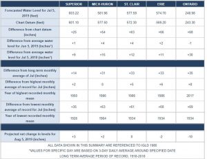
Water levels remain high across the Great Lakes. Over the last month Lakes Superior, Michigan-Huron, St. Clair & Erie have increased by 1, 4, 4, and 2 inches respectively. Lake Ontario has declined by 1 inch. Over the next month the forecasted levels meet or exceed the record high July monthly mean for all of the Great Lakes. Lakes Superior and Michigan-Huron are projected to see a net increase of 3 and 2 inches respectively, while Lake St. Clair is expected to have no net change in water level during the same period. Lakes Erie and Ontario are expected to decline 2 and 10 inches respectively over the next month.
Outflows from Lake Superior through the St. Mary’s River, and Lake Michigan-Huron’s outflow into the St. Clair River, are projected to be above average in July. Lake St. Clair’s outflow through the Detroit River is also forecasted to be above average.
![]()